Thursday, February 25, 2010

To the top of 'Tolt'

As a kid, I would hear people refer to the hill behind my grandfathers house in Norman's Cove, but I never quite got what they were actually saying. Was it "Tote" or "Toat" or "Toqe" or "Tope"??? I could never tell. But due to the wonders of the Internets, and the online Dictionary of Newfoundland English (thanks to my sister, Mandy, for telling me about it) . I was able to look it up, and low and behold, its "Tolt: A prominent rounded hill rising above the surrounding terrain"


About a month ago, on a Sunday afternoon, my wife and I went for short hike to the top of Tolt. We parked our car across from the "Dark Zone" and followed the ATV path into the base and climbed our way to the top. It was a bit icy on the rocks, but there were enough small trees and shrubs to get a hold of to pull our way to the top. What a beautiful view!

Looking south toward Chapel Arm


Looking north toward Long Cove, you can see the Bonavista peninsula far in the distance

Looking west down at Norman's Cove Pond

Wednesday, February 24, 2010

Spread Eagle Peak

A few weeks ago, Trent and I snowshoe'd to the top of Spread Eagle Peak, a whopping 693 ft above sea level. Its a wonder I didn't get pulmonary edema, haha! It was a great walk, about 3.5 hours round trip from the highway. It was my first time ever on snowshoes, as I usually ski, but I must say it was a lot of fun, and a great way to get over a hangover on a Sunday morning.


Monday, February 15, 2010

Dildo Island

Managed to get out on Saturday in the rain and drizzle for a few hours. Me and Trent paddled out around Dildo Island. We saw lots of eagles and a few seals. Total distance paddled was about 9 kms.

Dildo Island has some interesting history. From Wikipedia:

An archaeological excavation in 1995 discovered Dorset artifacts dated to between AD 150 and AD 750. It is believed that these people camped on Dildo Island for the purpose of seal hunting. From 1996 to 1999, archaeologist Silve Leblanc uncovered two Dorset houses and over 5500 artifacts from the same period.

In 2001 excavations were begun on a recently-discovered Indian site that radiocarbon dated to between AD 720 and AD 960. Evidence of a camp was found with the remnants of a wigwam and hearth. Almost all of the tools were made from purple and blue royalties that came from a source in Bonavista Bay roughly 145 km (90 miles) to the north.

John Guy's journal of 1612 suggested evidence of a Beothuk Indian camp on Dildo Island. An English fort was established in the early 1700s to defend the south side of Trinity Bay from the French during Queen Anne's War.

In 1889 a cod fish hatchery was constructed which was the largest in the world and the first in North America. The hatchery was created by Adolphus Nielson, a Norwegian.

For more information on Dildo Island, visit http://www.baccalieudigs.ca/dildo_island.asp

Anyways, we had a good paddle, it’s funny that in February I’m using my kayak more than my ski-doo.


On the beach in Dildo

Heading towards Dildo Head

Making the 1.35km crossing to Dildo Island

Looking at Dildo Island

On the beach on Dildo Island

Dildo Arm

Cliffs of Dildo Island


A seal, swimming on its back

Icefall on Dildo Head

Dildo Head

Old Shop

On Friday afternoon I managed to get out for a short paddle in Old Shop, Trinity Bay. It has been so mild for the past week, temps have been hovering around 0 and +1C. The winds were forecast to drop off in the afternoon so I hit the water at 3pm and paddled north towards Dildo Island, hugging the side of the peninsula. I don't often paddle solo, but given the right conditions and location, I get out from time to time. I paddled about 5 kms altogether and it was great to get on the water again after a month off. It was raining with drizzle, so most of my pictures were blurry, but here are a few. It sure was nice to get on the water again.


Lots of small stages along the way

Once past the houses, the coastline gets a little more interesting

Dildo Head, buried in the fog

Some icicles

Mini glacier

Heading back

Back to civilization

Thursday, February 11, 2010

Kayaking in Croatia: Kolocep Island

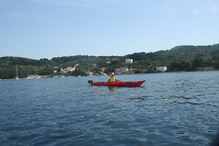
On our second day of paddling in Croatia, myself, Angie, 2 Aussies and our guide Marko paddled around Kolocep Island, about 18kms in total. The conditions were perfect, 32C and no wind at all. After about an hour on the water you could have made coffee from the water in my water bottle. All along this island are many cliffs and caves. One cave, called the blue cave, we got out of our kayaks and snorkeled into. Once inside all the water is very blue, from the reflection of the sun off the sandy bottom. It was amazing to say the least. On our way out of the water Angie stepped near a sea urchin and got some of it stuck in her toes, but we managed to get them out with tweezers, so there wasn't too much damage done.

When we got to the other side of the island, we stopped at a small village for lunch. The little villages are awesome, no roads, no cars....very quiet, and people live as they did for generations. After lunch we snorkeled in the cove for about 30 minutes, then paddled back to our started point, completing the circumnavigation of the island, which took about 5 or 6 hours altogether.

Lesson learned......put your bottle of water in the freezer the night before, then you have nice cold water all the next day.

Another amazing day in Croatia.